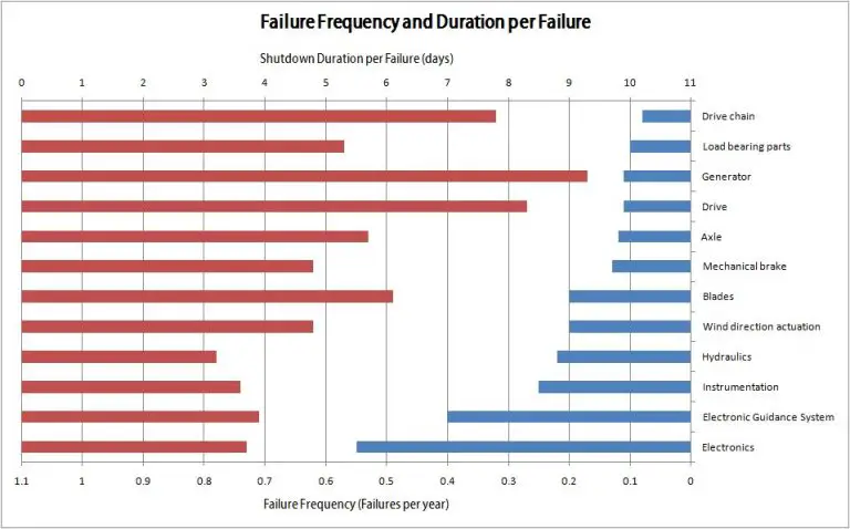
What Is The Main Reason Winds Form?
Have you ever felt a gentle breeze on your face on a warm day? Or been nearly knocked over by a gust of wind on a stormy afternoon? The movement of air that we call wind has a significant impact on our daily lives and the world around us. But have you ever stopped to wonder, what makes the wind blow in the first place? What forces cause air to move and create the winds we experience?
Wind is simply air in motion. It is produced by differences in atmospheric pressure, which push and pull air masses around the globe. There are several key reasons why winds form and understanding these causes can help us predict weather patterns and make sense of our windy world.
In this article, we will examine the main drivers that produce winds and make the air flow.
Uneven Heating
The sun is the principal source of heat in the Earth’s atmosphere. Solar radiation reaches the Earth’s surface unevenly, with the equatorial regions receiving more direct sunlight than the polar regions. This uneven heating sets up temperature differences in the atmosphere. Air expands when heated, becomes less dense, and rises. The rising warm air flows toward the poles and sinks where it is cooler. This cycle of convection drives the movement of air in the atmosphere which manifests as winds.
At the equator near the Earth’s surface, the air is heated most intensely by direct overhead sunlight. The equator can receive up to 4 kilowatts of solar radiation per square meter at noon. At the poles, the sunlight strikes the Earth at a steep angle, spreading the solar energy out over a larger area so the intensity is much less. The poles receive less than half a kilowatt of solar radiation per square meter at noon.
This difference in heating leads to large temperature differences between the equator and the poles. On average, the equator is 25°C warmer than the poles. These temperature variations cause differences in air pressure that make air move from high to low pressure, creating winds.
Pressure Differences
Uneven heating of the Earth’s surface creates areas of high and low atmospheric pressure. Warm air rises and expands, creating an area of lower pressure, while cooler air sinks and condenses, creating an area of higher pressure. The pressure gradient causes air to flow from high to low pressure zones in an effort to equalize the pressure differences. This movement of air from areas of high pressure to areas of low pressure is what we experience as wind.
On a local scale, the temperature differences between land and sea generate regions of high and low pressure that result in land breezes and sea breezes along coastlines. On a global scale, the atmospheric circulation between the equator and the poles creates prevailing wind patterns across latitudes. The pressure gradient force is strongest when the pressure difference between two locations is large. The greater the pressure difference, the faster the wind flows from high to low pressure zones.
Coriolis Effect
The Coriolis effect is a phenomenon caused by Earth’s rotation. As Earth rotates on its axis, the inertia of air moving near the surface causes it to appear to curve, or deflect. In the Northern Hemisphere, winds are deflected to the right. In the Southern Hemisphere, winds are deflected to the left. This apparent curving of the winds leads to the formation of major prevailing wind patterns that impact weather globally.
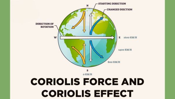
For example, the trade winds that blow from the subtropical high pressure belts towards the equator are deflected westward by the Coriolis effect in each hemisphere. The westerly winds that prevail at mid-latitudes are also a result of the Coriolis effect deflecting winds toward the east. So the rotation of the Earth plays a key role in the genesis and direction of winds all over the planet.
Mountain Ranges
Mountain ranges significantly impact wind patterns. As winds encounter mountains, the elevation forces the air to rise up and over the mountains. This disrupts and diverts the airflow, often creating regional wind patterns.
For example, the Rocky Mountains in North America lead to a number of localized winds. As westerly winds are forced up and over the mountains, the air warms and dries out, forming the Chinook winds on the eastern side of the range. The Chinook winds can be warm and fierce as they descend down the eastern slopes of the Rockies.
Therefore, mountain ranges create major disruptions in airflow, leading to unique wind patterns in the regions surrounding the mountains. The steep elevation changes force winds upwards, diverting them from their original track. This diversion of winds leads to localized and regional wind patterns that are distinct from the broader wind currents.
Land & Sea Breezes
The differential heating of land and sea surfaces during the day and night results in local circulation patterns known as land and sea breezes.
During the day, the land heats up faster than the ocean. The hot air over the land expands and rises, creating an area of lower pressure. The higher pressure air over the sea then moves in to fill this void, creating a cool breeze blowing from the sea towards the land. This is known as a sea breeze.
At night, the opposite effect takes place. The land cools down faster than the ocean due to differences in their heat capacities. The cool air over the land becomes denser and sinks to the surface, creating an area of higher pressure. The higher pressure then causes the warmer air over the sea to move towards the land, creating a breeze blowing from the land out towards the sea. This is known as a land breeze.
These daily oscillations in wind flow only occur along coastlines and to a limited depth inland. The land and sea breeze circulation patterns demonstrate how differential heating can cause pressure differences that result in local winds.
Weather Events
Major weather events like storms, weather fronts, and hurricanes create very windy conditions. The turbulent motions of these systems generate areas of differing air pressures that drive strong winds.
Thunderstorms demonstrate dramatic, small-scale wind activity. As warm, moist air rises in updrafts and then sinks in downdrafts, wind gusts whip through the storm system. Vertical wind shear is associated with supercell thunderstorms that can produce tornadoes.
The boundary between two air masses with different temperatures, humidity, or density is called a weather front. At cold fronts, the dense cold air wedges under the warmer air and pushes it up steeply, causing strong gusty winds. Warm fronts have milder winds as the warm air gently rises over the cold air.
Hurricanes spawn dangerous winds as air gets sucked into their low pressure center and vigorous updrafts and downdrafts develop in the storm’s feeder bands. The most intense winds are found in the eyewall surrounding the hurricane’s eye.
Jet Streams
Jet streams are fast, narrow air currents found in the upper levels of the atmosphere. They form due to the combination of atmospheric heating patterns and the rotation of the Earth underneath.
As air in the tropics is heated at the surface, it rises into the upper atmosphere. As it moves poleward, it cools and sinks again, creating large convection cells called Hadley cells. This rising motion near the equator and sinking motion further poleward drives strong upper level winds within the boundaries of the Hadley cells.
Additionally, the Coriolis effect caused by Earth’s rotation deflects those winds to the right in the northern hemisphere and to the left in the southern hemisphere. This combines with the convection cells to produce concentrated, fast moving rivers of air called jet streams.
The position and strength of jet streams has a major influence on weather patterns below, acting as guides for storms and moisture. By steering extratropical cyclones along their paths, jet streams play an integral role in day-to-day weather across the middle latitudes.
Conclusion
In summary, there are several key reasons that winds form on Earth. Winds are primarily driven by uneven heating of the atmosphere and Earth’s surface, which creates differences in air pressure. Air flows from areas of high pressure to low pressure, creating winds. The rotation of Earth also impacts wind patterns, causing deflection by the Coriolis effect. Major wind systems like trade winds and westerlies are driven by these pressure gradients and Earth’s rotation.
In addition, geographic features like mountain ranges and the contrast between land and sea can cause more localized wind patterns as air is channeled through mountain passes or circulates between land and sea to equalize temperature differences. Weather events like hurricanes also generate powerful winds by their intense low pressure centers. High-altitude jet streams form due to differences in air temperature and rotation.
In conclusion, the main reasons winds form on Earth include uneven atmospheric heating, pressure gradients, Earth’s rotation, geography, and weather events. Winds are a fundamental part of the global circulation system that distributes heat from the equator to the poles. Understanding the causes of winds helps meteorologists predict weather patterns around the world.
References
[1] NASA, “The Atmosphere: Getting a Handle on Carbon Dioxide. Sizing Up Humanity’s Impacts on Earth’s Changing Atmosphere: A Five Part Series.” https://climate.nasa.gov/news/2915/the-atmosphere-getting-a-handle-on-carbon-dioxide/, accessed March 2023.
[2] National Oceanic and Atmospheric Administration, “What is the difference between weather and climate?” https://www.noaa.gov/stories/what-s-difference-between-weather-and-climate, accessed March 2023.
[3] American Meteorological Society, “Extreme Winds: A Guide to Understanding Their Causes, Risks, and Predictions.” https://www.ametsoc.org/index.cfm/ams/publications/bulletin-of-the-american-meteorological-society-bams/extreme-winds-a-guide-to-understanding-their-causes-risks-and-predictions/, accessed March 2023.