What Is Wind And What Generates It?
What is Wind?
Wind is the movement of air from an area of high pressure to an area of low pressure. It is caused by the uneven heating of the Earth’s surface by the Sun. As the Earth’s surface absorbs and radiates heat at different rates based on factors like latitude, elevation, cloud cover, and surface features, regions of high and low air pressure are created.
Air naturally flows from high to low pressure. As a result, wind is generated as air flows across the planet, attempting to equalize the pressure differences. Wind flows in a variety of patterns based on global circulation and local geography. It can occur at different altitudes and exhibit varying speeds and directions based on the pressure systems driving it.
What Causes Wind?
Wind is caused primarily by the uneven heating of the Earth’s surface by the Sun. As the Sun’s rays strike the Earth, landmasses, bodies of water, and other surfaces absorb and lose heat at different rates. This creates areas of high and low air pressure. Air flows from high to low pressure areas, creating wind.
The rotation of the Earth also impacts wind patterns. This effect is known as the Coriolis force. It causes winds in the Northern Hemisphere to bend to the right and winds in the Southern Hemisphere to bend to the left.
The presence of mountains and bodies of water also affects wind flow. As wind encounters these barriers, it may speed up, slow down, change direction, or form eddies. Large mountain ranges like the Rocky Mountains in North America create major wind patterns.
Weather events like convection and differences in air density cause vertical air movement, which influences wind speed and direction. Thunderstorms, fronts, and other weather phenomena generate winds locally as air moves from one pressure system to another.
Global Wind Patterns
The major global wind patterns on Earth are created by the interactions between air circulation, the rotation of the planet, and solar heating. There are three major wind belts that encircle the globe: the trade winds, the westerlies, and the polar easterlies.
The trade winds blow from the subtropical high-pressure belts toward the equator in both the Northern and Southern hemispheres. These winds blow predominantly from the northeast in the Northern Hemisphere and from the southeast in the Southern Hemisphere. The trade winds meet near the equator, causing the warm, moist air to rise in the Intertropical Convergence Zone (ITCZ).
The westerlies are the winds in the mid-latitudes that blow from the high pressure area over the subtropical ridge towards the low pressure area around 60° latitude in both hemispheres. The westerlies originate from the polar vortex and are driven by the temperature gradient between the cold polar regions and the warm equator.
The polar easterlies blow from the high pressure polar regions towards the low pressure area of the Ferrel cell around 60° latitude. Like the westerlies, the polar easterlies are also influenced by the temperature differences between the poles and equator.
The Coriolis effect causes winds to curve to the right in the Northern Hemisphere and to the left in the Southern Hemisphere. This deflection is caused by Earth’s rotation and greatly influences the major global wind patterns.
Local Wind Patterns
Local wind patterns are caused by the different heating characteristics of land and sea as well as mountains and valleys. These local differences in heating lead to changes in air pressure that create localized winds.
Land/Sea Breezes
During the day, the land heats up faster than the sea, creating an area of lower pressure over the land. This causes the air to flow from the relatively higher pressure over the sea to the lower pressure over the land, creating a sea breeze. At night, the opposite happens – the land cools faster than the sea, so the higher pressure forms over the land and the lower pressure over the sea. This generates a land breeze blowing from the land out to sea.
Mountain/Valley Breezes
In a similar process, mountains and valleys generate localized winds. During the day, the mountainsides are heated by the sun, causing air to rise upslope. This creates an area of lower pressure that pulls air up from the valley below, generating a valley breeze. At night, the mountainsides rapidly cool while the valley stays relatively warm. The denser cooler air flows downslope as a mountain breeze.
Monsoons
Monsoons are seasonal winds generated by differential heating between large landmasses and the oceans. In summer, the large Asian landmass heats up significantly, creating an area of low pressure that pulls in moisture-laden air from the Indian and Pacific Oceans. This causes the heavy rains associated with the South Asian Monsoon. In winter, the landmass cools relative to the oceans, reversing the pressure gradient and winds.
High and Low Pressure Systems
One of the main drivers of wind is the movement of high and low pressure systems. High pressure systems are characterized by sinking air, which leads to clear skies. Low pressure systems have rising air, which causes clouds and precipitation to form.
In a high pressure system, the air at the surface is flowing outward from the center of the high pressure. This creates a clockwise circulation in the Northern Hemisphere and counterclockwise in the Southern Hemisphere. The outward moving air results in lighter winds.
In contrast, low pressure systems have rising air at the center. Air flows inward to the low pressure area, creating a counter clockwise rotation north of the equator and clockwise south of the equator. The inward moving air causes stronger winds than high pressure zones.
The movement of highs and lows across an area leads to changes in wind direction. Winds ahead of an approaching low pressure system will blow from east to west. Behind the system, winds shift and blow from west to east. This relationship between air pressure and wind direction is why weather forecasters look at pressure systems to predict wind conditions.
The stronger the difference in pressure between two adjacent high and low pressure zones, the stronger the pressure gradient. This steeper gradient causes winds to blow faster between the high and low. So the movement and strength of pressure systems is directly related to wind speed and direction.
Wind Speed and Direction
Wind speed refers to how fast the wind is blowing and is an important factor in predicting weather. Wind speed is measured using an instrument called an anemometer, which has cups or propellers that spin in the wind. The rate of rotation determines the wind speed. An anemometer can measure wind speeds of just a few miles per hour to over 100 miles per hour in very strong winds and storms.
Wind direction refers to the direction that the wind is coming from. Wind direction is reported as the cardinal direction the wind is blowing from, such as northerly, westerly, southerly, or easterly winds. Wind direction is measured using a wind vane, which is a device that spins to align itself with the wind. The end of the wind vane points in the direction the wind is coming from.
The Beaufort scale is also used to classify wind speed into different categories. The scale ranges from Force 0 for calm winds up to Force 12 for hurricane-force winds. At sea, the Beaufort scale relates wind speed to observed conditions on the ocean’s surface. On land, the effects of wind on objects such as trees are used. For example, Force 7 on the Beaufort scale (moderate gale) refers to wind speeds of 28-33 knots (32-38 mph) at sea and winds that cause large branches to sway on land.
Upper Level Winds
High above in the atmosphere, the winds can be quite strong. The upper level winds that have the most influence on weather are called jet streams. Jet streams are fast flowing, narrow air currents found in the upper troposphere and lower stratosphere, typically 7-12 miles above the surface of the Earth. Jet streams are characterized by winds speeds over 100 mph.
There are two main jet streams that impact weather patterns. The polar jet stream flows over the middle latitudes of the northern hemisphere. This jet stream separates the cold polar air to the north from the warmer subtropical air to the south. The polar jet stream tends to be strongest during the winter months and shifts south during the summer months. There is also a subtropical jet stream that flows eastward over the tropical latitudes, typically over 30 degrees north. This jet stream separates the tropical air masses from the extratropical air to the north.
The winds associated with jet streams have a major influence on the weather and storm systems at the surface. The polar jet stream brings storms and precipitation during the winter, while blocking storm systems in the summer. The subtropical jet stream influences tropical storms and can enhance areas of thunderstorm development. The winds and contours of the jet streams are important factors for meteorologists to analyze to understand expected weather patterns.
Extreme Winds
The strongest winds on Earth can be extremely dangerous and cause massive damage. Some extreme winds include hurricanes, tornadoes, and derechos.
Hurricanes
Hurricanes are powerful tropical storms that form over warm ocean waters and bring heavy rain, strong winds, and storm surges. Wind speeds in hurricanes can reach over 157 miles per hour. The strong winds of a hurricane can destroy buildings, down trees and power lines, spawn tornadoes, and cause deadly flying debris. Coastal areas are especially vulnerable to the storm surge flooding brought by hurricanes. Some of the most destructive hurricanes have been Katrina, Maria, and Harvey.
Tornadoes
Tornadoes are violently rotating columns of air that extend from thunderstorms down to the ground. The winds in tornadoes can reach speeds over 200 miles per hour. Tornadoes carve paths of destruction along their path, causing severe damage from extreme winds that can demolish homes and throw cars through the air. Tornadoes pose a deadly threat from their high winds and flying debris. Some historic tornado outbreaks include the Tri-State Tornado and the 2011 Super Outbreak.
Derechos
Derechos are widespread, long-lived wind storms associated with bands of rapidly moving showers and thunderstorms. Derecho winds can exceed 100 miles per hour and cause tornado-like damage. Derechos form in areas of contrasting temperatures and may be exacerbated by climate change. Recent derechos, like those in June 2012 and August 2020, left millions without power across the Midwest and Eastern U.S.
Wind Damage and Safety
Extreme winds can cause power outages, destroy property, and threaten human life. It is important to have a safety plan in place and take proper precautions when extreme winds are expected. Staying informed about weather alerts, having an emergency kit ready, and knowing where to take shelter can help keep you and your family safe during high wind events.
Importance of Wind
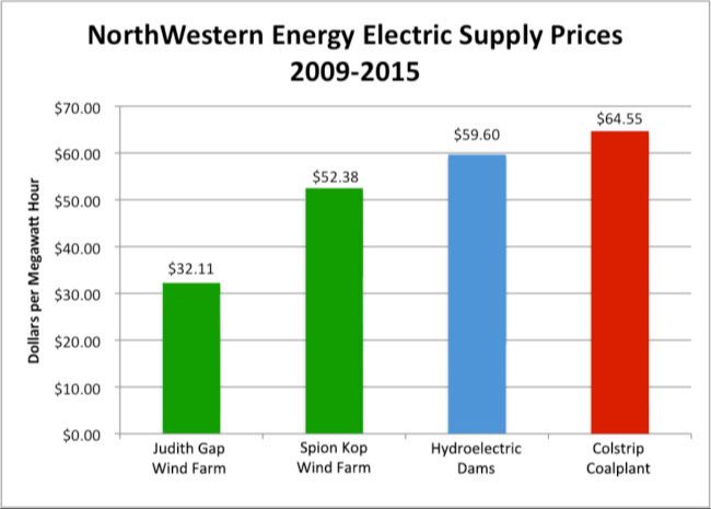
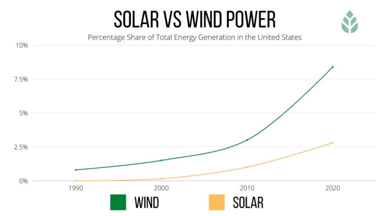
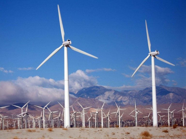
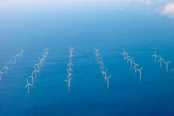
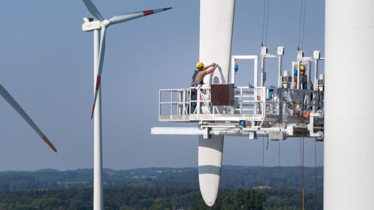
Wind plays a vital role across the world in many different ways. One of the most notable ways wind impacts life on Earth is through wind energy and electricity generation. Wind turbines convert the kinetic energy of moving air into mechanical power which is then converted into electricity. Countries like Denmark, Ireland, Germany, Spain, the United States and others generate a significant portion of their electricity from wind power. Wind energy is renewable, sustainable, and available around the clock.
Wind also greatly affects climate, weather, and ocean currents globally. The movement of air masses redistributes heat and moisture around the planet. This impact on global circulation patterns influences precipitation and temperature patterns. Wind-driven ocean currents like the Gulf Stream in the Atlantic transport warm water from the tropics northward, warming coastal areas of Europe and North America. Changes in wind patterns can alter climate and weather over time.
Fun Wind Facts
Wind has long captured our imagination and worked its way into myths, legends, and sayings. Here are some fun and fascinating facts about famous winds throughout history:
Famous Historic Winds
The Santa Ana winds are hot, dry winds that yearly blow through Southern California. Known for fanning wildfires, they are named after the Santa Ana Canyon where they originate. The Sirocco is a hot, dust-filled wind in North Africa and Southern Europe. This powerful wind can reach hurricane force and is known for impacting local weather and human health. Chinook winds are warm, dry winds on the eastern side of the Rocky Mountains. These powerful winds can reach 100 mph and dramatically raise temperatures.
Wind Records
The highest wind speed ever recorded was 253 mph during Tropical Cyclone Olivia off the coast of Australia in 1996. The windiest place on Earth is Commonwealth Bay, Antarctica which has averaged winds of 60 mph. Mount Washington, New Hampshire holds the world record for highest wind gust directly measured at 231 mph.
Wind Myths and Sayings
“Gone with the Wind” refers to something that has disappeared or faded away. “Three sheets to the wind” describes someone very drunk, unsteady on their feet. “Which way the wind blows” indicates being flexible and going with the prevailing opinion. These sayings show how wind has impacted language and culture across the globe.