What Is The Relationship Between Latitude And Solar Angle?
Definition of Latitude
Latitude is defined as the angular distance north or south from the earth’s equator measured through 90 degrees. Lines of constant latitude, known as parallels, run east-west and parallel to the equator. Parallels are used to indicate degrees of latitude north or south of the equator. The equator represents 0 degrees latitude. The north pole is at 90 degrees N latitude, and the south pole is at 90 degrees S latitude. On Earth, latitude lines range from 0 degrees at the Equator to 90 degrees North and South at the poles.
Latitude represents the north-south position of a point on Earth’s surface. Places that share the same latitude also share the same angle of solar incidence at noon on the equinoxes. Latitude is important in mapping locations and for navigation.
Definition of Solar Angle
The solar angle refers to the angle at which the sun’s rays reach the Earth’s surface. There are two components that make up the solar angle:
- Solar altitude angle – The angle between the horizon and the position of the sun in the sky. At solar noon, when the sun is at its highest point, the altitude angle is at its maximum.
- Solar azimuth angle – The angle measured clockwise from true north to the point on the horizon directly below the sun. In the northern hemisphere, the azimuth angle changes over the course of a day from east to west.
The solar altitude angle depends on the time of day, season, and latitude. At the equator, the maximum altitude angle is 90° when the sun is directly overhead at noon. As latitude increases, the maximum altitude angle decreases. The azimuth angle depends on the time of day and latitude. At solar noon, the azimuth angle is due south.
Together, the solar altitude and azimuth angles indicate the position of the sun in the sky at any given time and location on Earth. This directly impacts the intensity and angle at which sunlight reaches the Earth’s surface. Understanding solar angles is key for topics like climate, agriculture, architecture, and more.
(Source: https://quizlet.com/620468094/weather-and-climate-gateway-1-flash-cards/)
How Latitude Affects Solar Angle
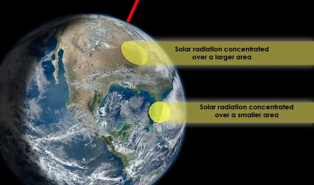
The latitude of a location on Earth determines how directly sunlight hits that area, which has major impacts on climate. At the equator, the sun’s rays strike Earth perpendicularly, so the energy is concentrated into a smaller area. The solar angle is 90° at the Equator. At the North and South Poles, the sun’s rays strike at a much lower angle, spreading the energy out over a larger area. The solar angle is 0° at the poles.
The farther away from the equator, the more oblique the angle of the sun’s rays on that location. Higher latitudes receive less direct sunlight than lower latitudes. The solar angle is greater at low latitudes near the equator and lower at high latitudes near the poles. For example, Miami, Florida at 26°N latitude receives more direct sunlight than Seattle, Washington at 47°N latitude. The lower solar angle at higher latitudes means the sun’s energy is spread out over a larger surface area, resulting in less concentrated solar heating and cooler average temperatures compared to the intense solar heating near the equator (source).
Solar Angle Changes with Seasons
The solar angle changes throughout the year as a direct result of the earth’s tilt on its axis. The earth is tilted 23.5 degrees relative to the plane of its orbit around the sun. This tilt is what causes the seasons as the earth revolves around the sun.
In the summer months in the northern hemisphere, the earth’s tilt positions that hemisphere to receive more direct sunlight. The solar angle is higher in the summer as the sun’s rays hit the surface more directly. According to research, at the summer solstice in the northern hemisphere, the solar angle can be up to 66.5 degrees at noon. This higher solar angle means increased intensity of sunlight and warmer temperatures.
In contrast, in the winter months, the tilt of the earth causes the northern hemisphere to receive sunlight at a lower solar angle. At the winter solstice, the solar angle at noon can be as low as 23.5 degrees in the northern hemisphere. This lower solar angle means sunlight is more indirect and weaker, leading to colder temperatures.
So as the earth orbits the sun throughout the year, the changing solar angles driven by earth’s tilt are directly responsible for the seasons and fluctuations in climate and weather.
Calculating Solar Angle
The solar altitude angle, or angular height, is the angle between the horizon and the center of the sun’s disc. It can be calculated for any location on Earth for any day of the year using the following formula:
Solar altitude angle = 90° – latitude + declination angle
Where:
- Latitude is the north/south angular location of a place on Earth measured from the equator in degrees.
- Declination angle is the position of the sun north or south of the celestial equator, which changes day-by-day due to the tilt of Earth’s axis. It can be calculated using the day number of the year.
- 90° represents the angle from the horizon to the zenith (directly overhead).
Subtracting the latitude gives you the angle from the southern horizon. Adding the declination gives you the angular height of the sun above the horizon for that latitude on that day.
This formula shows how latitude affects solar angle. Locations at higher latitudes will have lower solar altitudes, especially in winter when declination is negative. The sun will appear lower in the sky.
Solar Maps and Data
There are a number of solar angle maps and databases available that provide detailed information on the position of the sun in the sky based on location and time of year. These include:
The National Solar Radiation Database (NSRDB) from the National Renewable Energy Laboratory (https://www.nrel.gov/grid/solar-resource/solar-resource-maps.html), which provides data on solar radiation levels across the United States. This includes annual and monthly average daily total solar resource maps that show the amount of solar radiation reaching the ground.
PVWatts, also from NREL (https://pvwatts.nrel.gov/), is an interactive tool that calculates the solar potential for specific locations based on average monthly solar radiation and weather data for the area. Users can get solar angle information customized for the location they input.
Sunpath charts like the 3D Sun-Path tool (https://andrewmarsh.com/apps/staging/sunpath3d.html) demonstrate the relationship between latitude, time of year, and the position of the sun in the sky throughout the day. This can show sun angles for any given location.
This solar position data is important for proper siting and designing of solar energy systems to optimize solar capture. Knowing the availability and angles of sunlight over the year allows correct orientation and tilting of solar panels for maximum energy production. Solar maps and tools provide the detailed location-specific information needed for effective solar power system installation.
Impacts on Climate
The angle at which the sun’s rays strike the Earth has a dramatic influence on climate and seasons. As Earth orbits the sun, the tilt of its axis results in the sun striking the northern and southern hemispheres at different angles during the year. This causes solar energy to be more concentrated during summer months when the sun is more directly overhead, and more spread out in winter when the sunlight strikes at an angle.
According to the Encyclopedia Britannica, regions near the equator receive direct sunlight year-round which leads to consistently warm temperatures. But farther north and south of the equator, seasons become more pronounced. For example, during June in the Northern Hemisphere, the high sun angle leads to more concentrated sunlight and warmer summer temperatures. In December, the lower sun angle spreads out the sunlight resulting in colder winter temperatures.
The angle of the sun is the key driver of Earth’s climate zones. The tropics receive direct overhead sunlight, leading to a tropical climate. But higher latitude regions like the Arctic have a very low sun angle, even during summer, resulting in colder polar climates. The varying sun angle across the seasons and latitudes leads to large regional differences in temperature and precipitation patterns.
According to research from the University of Wisconsin, the low sun angle in polar regions means sunlight has to travel through more atmosphere. This leads to greater scattering and absorption of sunlight, reducing the amount of solar energy that reaches the surface. The low angle sunlight also spreads out over a larger surface area, reducing intensity. These factors contribute to colder average temperatures closer to the poles.
In summary, the tilt of Earth’s axis causes the angle of the sun’s rays to vary by latitude and season. This solar angle variation is the fundamental driver of climate patterns across different climate zones. The differences in regional and seasonal sunlight intensity and concentration have a profound impact on temperature, precipitation, and overall climate.
Architecture and Design
The solar angle has a major impact on architecture and design. Building orientation is a crucial consideration to optimize passive solar heating and cooling. Properly orienting a building to account for solar angles can reduce the need for mechanical heating and cooling systems. South-facing walls and windows receive more direct sunlight in the Northern Hemisphere, making south orientation ideal for solar heat gain in the winter. East and west orientations can be used for solar heat gain in the morning and afternoon, respectively. However, east and west-facing windows lead to greater overheating issues in the summer.
Optimizing solar angle is also key for daylighting in buildings. Carefully positioning and angling windows relative to sun paths and solar angles maximizes natural interior daylight while minimizing glare. For example, windows placed high on a south wall and angled downward can allow low winter sun to penetrate deep into a space while blocking high, intense summer sun. Computer modeling of sun angles and simulations enables architects to design fenestration and shading systems tailored to the solar orientation.
Proper solar orientation and design helps reduce building energy costs and enhances occupant comfort and wellbeing. Understanding the movement of the sun and how solar angles impact a specific location is crucial for creating optimal, high-performance architectural designs.
Agriculture and Ecology
The angle of incoming solar radiation has a significant impact on agriculture and natural ecosystems. Growing seasons and crop yields are strongly influenced by the duration and intensity of sunlight in different seasons. At higher latitudes, the sun sits lower in the sky year-round. This means sunlight is spread over a larger surface area, reducing the intensity of incoming radiation. The lower peak solar angles near the poles result in colder average temperatures that shorten the active growing season for most crops.
In equatorial regions, the high solar angle leads to more direct sunlight and a consistent growing season year-round. The intense overhead sunlight can maximize photosynthetic activity when sufficient water is available, leading to higher potential crop yields. However, excessively direct solar radiation also increases evapotranspiration rates and the risk of heat or moisture stress on plants (source).
Solar angle and duration also influence the types of natural habitats and ecosystems that develop in a region. More direct sunlight tends to lead to grasslands and deserts, while more tilted solar angles allow denser forests to develop. The seasonal variation in sunlight triggers natural cycles of plant growth and dormancy attuned to each latitude and climate (source).
Understanding these solar patterns allows farmers and ecologists to plan crops and conserve habitats for maximum solar efficiency and sustainability.
Solar Angle in Space Science
Solar angles play an important role in space science for understanding the amount of sunlight reaching different planets and moons. The angle at which sunlight strikes a planetary body affects its climate and surface temperatures. Solar angles are also critical calculations for space missions, astronomy observations, and operating solar-powered spacecraft.
On other planets, solar angles vary widely based on the tilt of the planet’s rotational axis and its position in orbit around the sun. For example, on Uranus the solar angle changes from near 0° to near 98° over the course of its 84-year orbit due to the planet’s extreme axial tilt of 98° (Solar Incidence Angle). Mars also has greater variations in solar angle than Earth due to its orbital eccentricity.
To accurately target locations on planetary bodies for landing spacecraft, solar angles must be precisely calculated. Navigating spacecraft also relies on understanding solar angles and how they change. The solar incidence angle directly impacts the energy generated by solar panels on satellites and rovers (Penn State).
In astronomy, accounting for solar angle is critical when observing the Sun and taking measurements. The position of the Sun in the sky shifts over the course of a day and throughout the year. Astronomical calculations adjust for this changing solar angle. Specific solar angles like solar altitude are used to determine characteristics of the Sun and its activity.