What Causes Wind Environment?
Wind is the natural movement of air across the Earth’s surface. Understanding what causes our planet’s wind patterns is crucial for several reasons. Wind impacts climate, weather, agriculture, infrastructure, and energy production. Knowing the root causes behind wind gives us greater ability to predict the weather, harness wind power, protect crops and property from damage, and more.
In this article, we will explore the major factors that influence wind flow around the world. By looking at uneven heating, the Coriolis effect, mountain and surface effects, and global circulation cells, we can gain insight into the fundamental forces that shape the wind environment on Earth.
Defining Wind
Wind is defined as air in motion. It occurs when a mass of air molecules move from areas of high pressure to areas of low pressure. The greater the difference in the atmospheric pressure between two locations, the faster the wind speed. Wind is an important part of the weather and climate system.
Wind has the following key properties:
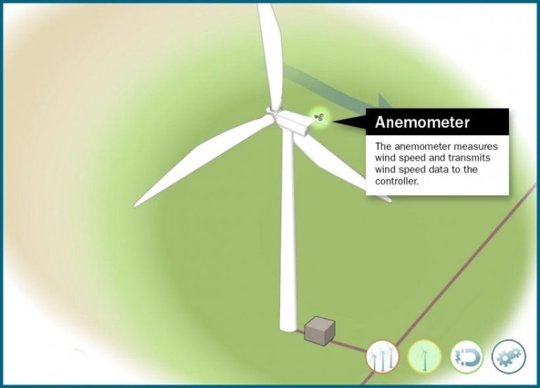
- Speed – how fast the air is moving, measured in knots, miles per hour, or meters per second.
- Direction – where the wind is coming from, described by cardinal direction (N, S, E, W) or degrees from North.
- Variability – wind is always changing speed and direction, due to differences in pressure.
Other factors that characterize wind include gusts, squalls, turbulence, and blasts. Understanding the typical wind patterns in an area is important for meteorology, construction, agriculture, aviation, sailing, and many other fields.
Global Wind Patterns
On a global scale, wind patterns are primarily driven by the temperature differences between the equator and the poles. This temperature difference causes air masses to circulate between the equator and the poles, creating recognizable wind belts around the planet.
Some of the most prominent global wind patterns include:
- Trade winds – These winds blow from the subtropical high pressure belts towards the equator in both hemispheres. The trade winds in the Northern hemisphere blow from the northeast, while the trade winds in the Southern hemisphere blow from the southeast.
- Westerlies – The westerly winds are the prevailing winds blowing from west to east between the trade winds and polar easterlies in the middle latitudes of both hemispheres. These winds originate from the subtropical high pressure belts and are generally stronger in winter.
- Polar easterlies – The polar easterlies or the polar vortex are the cold, dry winds blowing from the high pressure systems over the poles. They blow from the northeast in the Northern Hemisphere and southeast in the Southern Hemisphere towards the low pressure at the poles.
These large-scale wind patterns transport heat from the equator towards the poles and influence local wind patterns all over the world. They are primarily driven by the rotation of the Earth and the atmospheric circulation cells set up by the temperature differences between the equator and the poles.
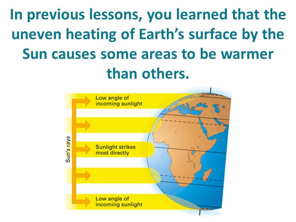
Uneven Heating
The sun’s rays heat the Earth’s surface unevenly, causing air temperature variations that create horizontal pressure differences and generate wind. The regions of Earth located nearer to the equator receive more direct sunlight than the poles. This causes the equatorial areas to be warmer than the polar regions. Warm air is less dense and exerts less atmospheric pressure than cool air. The differences in air pressure cause air to flow from high to low pressure, creating wind.
On a more localized scale, the land heats up and cools down more quickly than the oceans. During the day, the land warms faster than the adjoining sea, decreasing the air pressure over the land. The higher pressure over the sea causes the air to flow from the sea to the land as a sea breeze. At night, the opposite effect happens as the land cools faster than the sea. The higher pressure over the cool land causes the air to flow from the land out to sea as a land breeze.
Coriolis Effect
The Coriolis effect is one of the major influences on global wind patterns. It refers to the apparent deflection of moving objects when viewed in a rotating reference frame. On Earth, the reference frame is the planet’s rotation on its axis.
Because the Earth rotates eastward, moving objects like air currents appear to be deflected rightward in the northern hemisphere and leftward in the southern hemisphere. This is due to the inertia of the moving object. At the equator, the Coriolis effect is nil.
The Coriolis effect helps explain why winds circulate clockwise around high pressure systems in the northern hemisphere, but counter-clockwise around low pressure systems. The opposite is true in the southern hemisphere. It creates belts of easterly winds at low latitudes near the equator and westerly winds at higher latitudes.
Overall, the Coriolis effect creates major circulating wind patterns across the planet. It influences the direction of the trade winds, westerlies, polar easterlies, and jet streams. The Coriolis effect is strongest at the poles and weakest at the equator. It plays a fundamental role in global atmospheric circulation patterns.
Mountain Effects
Mountains can significantly impact local wind patterns due to the uneven heating between the mountain slopes and nearby valleys. During the day, the mountain slopes receive direct sunlight and heat up much faster than the shaded valleys below. The warm air on the mountain slopes becomes less dense and rises, creating an upslope wind. Meanwhile, the relatively cooler and denser air in the valley sinks and flows downslope, creating a valley breeze.
At night, the pattern reverses – the mountain slopes rapidly cool without sunlight while the valleys remain relatively warm. The cooler denser air at the mountain slopes flows downslope as a mountain breeze, while the warmer air in the valleys rises and flows upslope, creating a valley breeze.
These regular mountain and valley breezes are examples of local thermally-driven circulation. The size and orientation of the mountains and valleys can strengthen these wind patterns. Large mountain ranges like the Rockies or Himalayas can even influence wind patterns on a continental scale.
Land/Sea Breezes
Land and sea breezes are caused by the temperature differences between land and sea. During the day, the land heats up more quickly than the sea due to its lower heat capacity. This causes the air above the land to warm and expand, becoming less dense than the cooler air above the sea. The hotter, less dense air rises, creating an area of lower pressure over the land. The higher pressure, cooler air over the sea then moves in to replace the rising warm air, creating a sea breeze blowing from the sea to the land.
At night, the opposite happens. The land cools more quickly than the sea due to differences in heat capacity. The air above the land becomes cooler and denser than the air above the sea, creating an area of higher pressure over the land. The cooler air sinks over the land, causing the warmer air over the sea to move in. This creates a land breeze blowing from the land out to sea.
These daily oscillations in wind direction are most noticeable along coastlines and around large lakes. Land and sea breezes typically affect areas within a few tens of kilometers from the coast. The strength and direction of land and sea breezes can impact local weather patterns and cloud formation.
Urban Heat Islands
Cities with dense concentrations of concrete, asphalt, and other surfaces that absorb and retain heat create what are known as urban heat islands. During the day, these surfaces absorb large amounts of heat from the sun. At night, they gradually release this heat into the atmosphere, causing temperatures in urban areas to remain higher than surrounding rural regions.
These elevated temperatures in urban heat islands can significantly impact local wind patterns. As the urban surfaces release heat, they warm the air directly above them. This warmer air is less dense than the cooler air above rural areas. The differences in air density create pressure gradients that cause the warm air to rise over the city. The rising warm air pulls in cooler air from the outskirts, creating a circulation pattern. This results in localized urban breezes blowing from the rural areas into the urban center.
The strength of these urban breezes depends on the temperature difference between the city and surrounding region. Larger cities with more concentrated urban areas and taller buildings produce stronger heat islands and temperature gradients. This leads to increased local wind speeds flowing into the urban core, especially at night. The urban heat island effect is yet another example of how differences in temperature can drive wind flows at a local scale.
Jet Streams
Jet streams are fast flowing, narrow air currents found in the atmosphere at around 30,000 feet above the surface of the Earth. Jet streams form along the boundaries of adjacent air masses with significant differences in temperature, such as the polar region and the warmer subtropical region.
The position and strength of jet streams has a major influence on the weather and climate of the regions below it. The winds blow from west to east in jet streams but meander north and south. These meanders, called Rossby waves, transport cold and warm air across the middle latitudes and cause shifts in surface pressure and precipitation patterns.
When the jet stream dips southward over an area, it brings cooler air, increased wind speeds, and stormy weather. When the jet stream shifts northward, warmer air, calmer winds, and milder weather tends to occur beneath it. The length of time the jet stream spends over an area determines the duration of cooler/warmer and unsettled/fair weather.
Therefore, the movement of major jet streams contributes to surface wind patterns and influences day-to-day weather events and longer-term climate shifts across the mid-latitudes of the globe.
Conclusion
Understanding the causes of wind and wind patterns is incredibly important. Wind impacts almost every aspect of our lives, from weather and climate to renewable energy production. This article provided an overview of the key factors that influence wind patterns around the world.
The uneven heating of the Earth by the sun is the ultimate driver of global winds. But the rotation of the Earth also plays a major role through the Coriolis effect, which deflects winds and contributes to circular wind patterns. Topographical features like mountains can funnel and accelerate winds, while differences between land and water surfaces create local wind effects like land and sea breezes. Even cities impact winds through the urban heat island effect.
By summarizing the causes behind our planet’s intricate wind systems, from global circulation patterns down to local winds, it is clear how complex and interconnected Earth’s atmosphere is. Appreciating these relationships allows us to better understand day-to-day weather, make climate models more accurate, and harness the winds for renewable power. Just like the atmosphere itself, knowledge builds upon itself, and the more we learn the better we can predict, prepare and protect as the winds continue to shape our world.