How Are Strong Winds Formed?
Strong winds are generally defined as sustained winds reaching or exceeding 25-30 mph. They arise due to differences in air pressure that drive air movement from areas of high pressure to low pressure. The greater the pressure difference, the stronger the resulting winds become.
Winds form all across the planet due to the complex interactions between the sun, rotation of the earth, and uneven heating of the surface. Global circulation patterns transport heat from the equator towards the poles. Meanwhile, more localized differences in temperature, moisture, and pressure result in common wind patterns we experience regularly. Under certain conditions, winds can accelerate to extreme speeds in the form of storms, jet streams, or other rapidly moving air currents.
Global Wind Patterns
Global wind patterns are primarily driven by differences in air pressure and temperature around the world. Air flows from areas of high pressure to areas of low pressure. The sun heats up air at the equator, causing it to rise and flow toward the poles. As this hot air rises, cooler air flows in along the surface to replace it, creating wind circulation cells. The rotation of the Earth also impacts global winds through the Coriolis effect, which causes winds to curve to the right in the Northern Hemisphere and to the left in the Southern Hemisphere.
The resulting major global wind belts include the trade winds, westerlies, and polar easterlies. The trade winds blow from the subtropical high pressure zones toward the equator in the tropics. The westerlies blow from the subtropical highs towards the poles in the mid-latitudes. And the polar easterlies blow from the polar high pressure zones toward the mid-latitudes near the poles. The interactions between these wind belts drive weather patterns around the world.
Local Wind Patterns
Local wind patterns are winds that are generated due to smaller geographic features and temperature differences within a local area. Here are some of the main types of local wind patterns:
Land/Sea Breezes
Land/sea breezes are winds that develop due to the temperature difference between the land and the sea. During the day, the land heats up faster than the sea, creating warmer air temperatures over the land. This causes the lower air pressure over the land to draw in the cooler air from over the sea. At night, the opposite happens – the land cools down faster than the sea, creating cooler air temperatures over the land. This causes the higher pressure over the sea to push air inland.
Mountain/Valley Winds
Mountain and valley winds are generated due to the temperature differences between the mountains and the nearby valleys. During the day, the mountain slopes receive direct sunlight and heat up quickly. The hot air rises up the mountain slopes, causing an upslope wind. At the same time, the cooler denser air flows down the mountain into the valley, creating a downslope wind. At night, the mountain slopes cool rapidly, reversing the winds – cool air flows down the mountain while warmer winds blow up the valley.
Monsoons
Monsoons are seasonal reversing winds accompanied by corresponding changes in precipitation. They are caused by the difference in temperature between large landmasses and adjacent ocean waters. In summer, the land heats up much more quickly than the ocean, causing the hot air over the land to rise. This draws in moist air from over the ocean, resulting in heavy rainfall. In winter, the land cools down faster than the ocean, causing the air over the land to sink and dry conditions to prevail.
Extreme Winds
Some of the strongest and most destructive winds on Earth occur during extreme weather events. Downslope winds, thunderstorm downdrafts, derechos, and hurricanes can all generate exceptionally intense winds.
Downslope winds like the Santa Ana winds in California form when air descends rapidly down the leeward slopes of mountains. As the air sinks, it compresses and warms, increasing wind speeds dramatically. Gusts can exceed 100 mph in extreme downslope wind events.
Thunderstorm downdrafts occur when rain-cooled air descends from the base of a thunderstorm, spreading strong winds outwards upon reaching the ground. These gust fronts can cause extensive wind damage.
Derechos are widespread, long-lived windstorms associated with fast-moving bands of severe thunderstorms. Derecho winds can gust over 100 mph and cause tornado-like damage along paths that extend for hundreds of miles.
Among the strongest winds on Earth are those in hurricanes. The spiraling thunderstorms in a hurricane’s eyewall can generate winds exceeding 150 mph. Hurricane winds can destroy structures, fell trees, and cause devastating storm surges along coastlines.
Jet Streams
Jet streams are fast flowing, narrow air currents located in the upper levels of the atmosphere. They are typically thousands of kilometers long but only a hundred or so kilometers wide. Jet streams form along boundaries of adjacent air masses with significant differences in temperature, such as near the polar front between cold polar air and warmer tropical air. The large temperature contrast creates horizontal gradients of air pressure that accelerate the air flowing west to east in the upper troposphere. These narrow belts of especially fast winds blow as fast as 250 mph in the core of the jet stream.
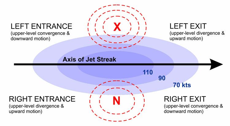
Jet streams have a major influence on weather patterns at mid-latitudes. The location and strength of the jet stream steers surface weather systems and storm tracks. Southward undulations in the jet stream trap cold Arctic air to the north while northward undulations allow warm tropical air to surge northward resulting in heatwaves. The speed of the jet stream also impacts weather, with a faster jet stream leading to stronger surface winds and storminess. Overall, jet streams play a crucial role in creating day-to-day weather variability in the mid-latitudes as well as steering extratropical storms.
Mountain Waves
Mountain waves, also known as gravity waves, are a unique weather phenomenon that occurs when stable air flows over a mountain range. As the wind hits the mountains, it is forced upward and causes oscillations in the atmosphere. The air flows up and over the mountains in a wave-like pattern, with alternating crests and troughs.
As the air ascends the mountain on the windward side, it expands and cools adiabatically. When it crests the summit, it sinks on the leeward side and is compressed, warming adiabatically. This oscillation between compression and expansion creates the wave-like pattern.
Mountain waves can create significant turbulence and downdrafts in the lee of the mountains. When the air descends, it can accelerate to high speeds, sometimes exceeding 100 mph. This can create dangerous conditions for aviation and contribute to the formation of rotors, powerful eddy currents that can flip aircraft.
While mountain waves pose hazards, they also create stunning visuals in the atmosphere. Lenticular or lee clouds often form at the crest of these waves and can create striking displays.
Low Level Jets
Low level jets are narrow bands of high speed wind that occur close to the surface of the earth, usually below 1,500 meters (5,000 feet) in altitude. These fast moving streams of air are most commonly found overnight as the ground rapidly cools after sunset.
As the sun goes down, the ground loses heat through radiation much faster than the air above it. This creates a temperature inversion, where the air closest to the surface is cooler than the air higher up. The large temperature difference between the cool surface air and warmer air aloft causes the atmosphere to become very stable and resistant to vertical motion.
Within this stable layer, winds increase significantly in speed with height. The maximum wind speeds are found a couple hundred meters above the ground, forming a concentrated jet of fast moving air. Though these winds blow at low altitude, low level jets can reach speeds over 50 knots (90 km/h), with some achieving over 100 knots.
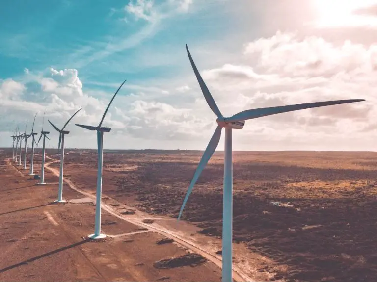
The jet typically forms around sunset as the ground cools, then dissipates after sunrise as daytime heating eliminates the temperature inversion. Low level jets play an important role in transporting heat, moisture, and air pollution overnight. They are also critical for powering wind turbines after dark.
Gap Winds
Gap winds are strong winds that are formed when air is funneled through a narrow gap in topography, accelerating the wind speed through that gap. Some of the most well known examples are the Santa Ana winds of California.
The Santa Ana winds occur when high pressure builds over the Great Basin area of the Western United States. This high pressure system causes air to accelerate through gaps in the mountains along the coast, from the high desert areas into the Los Angeles basin and down towards San Diego. As the air is compressed through these gaps, its speed increases dramatically, resulting in extremely hot, dry winds that can reach speeds of 50-100 mph.
Other examples of gap winds include the Bora winds of Croatia, the Mistral in France, and the Foehn winds of the Alps. In each case, the winds are formed by air being squeezed through mountain passes or gaps, which accelerates their speed.
The compressed nature of gap winds means they can be extremely gusty and turbulent. The high winds can whip up massive wildfires, as has happened many times with the Santa Ana winds in California. Overall, gap winds demonstrate the powerful effects that geography and topography can have in channeling and strengthening winds.
Future Changes
Climate change is expected to impact wind patterns around the globe in coming decades. As average global temperatures rise due to increased greenhouse gas emissions, wind circulation patterns are likely to shift. Some regions may experience decreases in average wind speeds, while other areas may see more intense and extreme wind events.
Scientists project that climate change will alter large-scale wind patterns like the jet stream. A wavier and slower-moving jet stream could lead to more stagnant weather patterns, contributing to droughts, heatwaves, and flooding. The polar jet stream circumnavigates the northern hemisphere in the mid-latitudes. As the Arctic warms at a faster rate than global average temperatures, known as Arctic amplification, the temperature difference between northern latitudes and more southern regions is decreasing. This reduces the strength of jet stream winds.
There is evidence that climate change is already increasing wind storm frequency and intensity in certain regions. Rising sea surface temperatures provide more energy for tropical storms. Climate models predict increased hurricane intensity and precipitation rates, as well as expanded ranges for tropical cyclones. Models also project a poleward shift of the storm tracks in both hemispheres. This would extend the range of strong extratropical cyclones and their associated winds.
Climate change impacts on local wind patterns are complex and will vary by region. But it is clear that continued global warming will have significant effects on winds worldwide. Planning for and adapting to shifting wind regimes will be crucial in the coming decades. Reducing greenhouse gas emissions can help limit the changes. But some alteration of global and regional wind patterns appears inevitable as climate change continues.
Conclusion
In summary, winds form on both global and local scales due to differences in air pressure and the rotation of the Earth. On a global scale, wind patterns like trade winds, westerlies, and polar easterlies form due to the temperature contrast between the equator and the poles. Locally, winds form due to more minor differences in pressure caused by temperature differences between land and sea, mountains and valleys, and daytime heating and nighttime cooling.
We also looked at some extreme wind events like jet streams, mountain waves, and low level jets. Jet streams form due to major temperature contrasts between air masses in the upper atmosphere. Mountain waves occur when winds are forced up and over mountain ranges, creating dangerous turbulence on the leeward side. Low level jets are regions of fast moving air that occur at night when surface cooling stabilizes the lower atmosphere.
Understanding how winds form can help us predict wind patterns and prepare for extreme wind events that may affect aviation, buildings, and people.